You are using an out of date browser. It may not display this or other websites correctly.
You should upgrade or use an alternative browser.
You should upgrade or use an alternative browser.
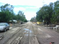
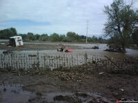
1 sad photo from Evans, CO
- Thread starter JPhil
- Start date
mrvette
Phantom of the Opera
Mommy nature is a bitch alright, next year you all be back to fire season....
We lost 6 catfish to drowning in the swamp so far this month.....
 :ghost:
We lost 6 catfish to drowning in the swamp so far this month.....
JPhil
Huh?
I guess it's a bit hard to see what my picture is, but it's a C2 coupe body shell that washed out of the auto wrecking yard across the street behind me. It traveled at least several hundred yards and cleared the fence in the foreground. Who know what shape it was in before, but there sure ain't much left now.
Many other vehicles from this yard, a lot of good old stuff, washed into the fields and buried & destroyed up and down the road as well.
Horses & livestock too.
The road behind me here in this photo below is half washed out, just a couple hundred yards farther up it is gone, just gone.
There were many more pics I could have taken, but I didn't want to seem a ghoul.

Last edited:
MYBAD79
Moderator
Damn, this was right in your neighborhood?? Didn't really "click" when I saw the flooding in the news..... Are you ok ???
Last edited:
DeeVeeEight
Fast Pedalphile
Damn, this was right in your neighborhood?? Didn't really "click" when I saw the flooding in the news..... Are you ok ???
X2. Keep us posted please.
JPhil
Huh?
I came through unscathed, never even lost power. I'm about a mile from and 100' above the Big Thompson, in the city of Loveland where the river comes out of the mountains.
My sister in Estes Park also survived with no damage, she's way above the river. But they are without sewer now, and all roads to Estes were destroyed except Trail Ridge which is narrow & twisty over the continental divide (at 12,000 feet) from the Western Slope. It will be closed from snow in a matter of weeks.
My Mom lives in Boulder, in the house I grew up in, about 10 blocks from Boulder Creek and a couple hundred feet above. She's fine also.
One of my oldest friends lived in Jamestown, which was pretty much wiped off the map. Nobody has heard from him yet.
It's only 40 miles between Boulder and Loveland, going through Lyons & Longmont along the way.
All the drainages from the mountains north of Colorado Springs drain into the South Platte River, which cuts across the corner of Evans, a smaller town right next to Greeley. Greeley is 20 miles due east of Loveland, that's where I work. We also do the building inspections for Evans.
The highest ever recorded flood of the So Platte in the Evans area was 11 feet, in 1965. This time it was almost 20 feet.
Almost all the roads are damaged or destroyed. Interstate 25 and State Highway 85 out east are open north-south, but virtually every other road is damaged enough at some or many places in all the affected counties to make travel a real challenge. Almost all the canyon roads are destroyed. It will take years to recover from this......
http://www.theatlantic.com/infocus/2013/09/colorado-flooding-after-the-deluge/100594/
The second photo, the aerial one, is looking west. I don't recognize the subdivision in the foreground, it's probably farther east in Weld County, but Loveland would be back at the foot of the mountains and that city toward the upper right might be Greeley/Evans.
Several photos farther, the yellow sign that says "Big Thompson Indian Village" was a souvenier shop up the canyon just a few miles west of Loveland, with tee-pees and camping and all. The river's original course is way up to the left. There was an old rusty 1920 or so Essex or something up on blocks next to the sign.
Out along the county roads, the smell of dead animals half buried in the mud and bloating in the sun is beginning to waft through the air. Farm trucks with stiff hooves sticking up in the back on the roads......
Last edited:
denpo
Carburated Nihilist
Wow, that was serious shit, glad you made it through.
mrvette
Phantom of the Opera
:gurney: Apparently I was like 3 years old, Dad moved us to West Virginia, bought a house on a hillside, and watched some hurry cain/storm flood out everyone at bottom of the hill, and so his advice was to never buy a house at bottom of the hill....he never did....
And so at age 53, moving to Florida from Maryland, I started house hunting, simple cut sheet, small house, masonry/block/brick, slab, and have some elevation to it.....took about 5 solid days to find this one, with some 30' elevation off the swamp that drowns those catfish.....the swamp has claimed some 30 homes adjoining it, done that THREE times since I moved here in '97, last time was the worst, last summer/fall.....just about this time of year....
They call it a 'Bird Sanctuary'......bullshit, it's a swamp.....and the road paralleling it is about a mile long with the streets on the hill all T into that long road....:gurney:
Kid Vette
Master-Baiter
Wow, that was serious shit, glad you made it through.
Ditto. :amazed:
Latest posts
-
-
-
-
-
-
-
-
Was member years ago dropping by to say hello.
- Latest: crazyhorse
-
-
-
-
-

